

Shiprock: Photographing the Rock with Wings
Sacred Navajo Volcanic Formation & Dramatic Desert Photography
Shiprock Highway 64 View | ISO 500 / 115mm / f/7.1 / 1/640 sec
🎯 In case you were wondering …
Where is the best place to photograph Shiprock?
The most dramatic photography location is along Indian Service Route 13 (ISR 13), south of the formation. From this paved road, you can align the massive volcanic dyke (a 30-foot tall rock wall) as a leading line pointing directly at the peak. A telephoto lens (200mm+) is required as the formation is still 1-2 miles away.
And now for the rest of the post!
| Location / Viewpoint | GPS Coordinates | Best Time & Light | Recommended Lens | Photography Tips |
|---|---|---|---|---|
| Route 13 Dyke View (South) | 36.639300, -108.868700 | Sunrise Golden light hits the "fin" |
70-200mm or 100-400mm Compress dyke leading line |
Park completely off pavement. Walk along the road to align the volcanic wall with the peak. |
| US-491 Roadside (East) | 36.695000, -108.765000 | Sunset Silhouette against colorful sky |
200-500mm Formation is ~4 miles away |
Best for "Big Sky" shots. Capture the full width of the formation rising from the flat desert. |
| Highway 64 (North) | 36.782000, -108.885000 | Stormy Weather / Afternoon Dramatic mood |
Wide Angle or Tele Environmental context |
Offers a different profile of the rock. Good for capturing storms rolling in over the plains. |
⛰️ Shiprock Quick Facts
Location: Northwestern New Mexico, 15 miles SW of Shiprock town; Coordinates: 36.6875° N, 108.8372° W
Height: 1,583 feet above desert floor | Summit Elevation: 7,178 feet elevation above sea level
Age: 27-30 million years old (volcanic plug)
Navajo Name: Tsé Bitʼaʼí ("Rock with Wings")
Access: View ONLY from paved roads (Route 13, US-491) | Visible 30-50 miles away
Best Viewpoint: Indian Service Route 13 near volcanic dyke
Best Time: Sunrise or sunset | Golden hour light
Essential Gear: 200-400mm telephoto (formation is 1-3 miles from road)
Entry Fee: None (viewing from public roads)
⚠️ PROHIBITED: Climbing, camping, driving on dirt roads, drones (without permit)
🎯 Bottom Line: This is SACRED land. Photograph only from paved roads. Use long telephoto lenses. Sunrise from Route 13 shows the volcanic dyke leading to the peak. Respect Navajo culture absolutely.
Stumbling on Shiprock
View of Shiprock from Rte 491 with Indian Access Road in view
I was miles away when Shiprock first flickered on the horizon. The torrential rains had just started slowing and the low clouds and dense fog had begun to lift from the high desert plateau of northwestern New Mexico. As I squinted past the frenetic, turbo-charged wipers of my car rental, the massive black fin of what could only be described as a monolithic land shark took shape on the horizon.
Like the Navajo centuries before, I had to investigate this incredible structure. As it turns out, I had unexpectedly stumbled on Shiprock.
In better weather, Shiprock is visible from 50 miles away. Highway travelers from Farmington to Cortez can't help but watch it grow larger, darker, more dramatic with each mile. And once you've seen it—really seen it—Shiprock is impossible to forget.
The Navajo know it as Tsé Bitʼaʼí—"Rock with Wings." According to Navajo tradition, the massive rock formation is the remains of the great bird that carried the Navajo people to their homeland from the north. The bird, exhausted from its journey, transformed into stone, its wings spreading south and east across the desert as the volcanic dykes we see today.
For photographers, Shiprock represents something equally powerful: a subject so stark, so isolated, so inherently dramatic that it demands to be photographed. But photographing it requires understanding not just light and composition, but deep respect for Navajo culture and sacred space.
This isn't Monument Valley, where you can drive a loop and shoot at will. This is sacred ground, and you'll photograph it from a distance—or not at all.
Best Viewpoints for Photographing Shiprock
Shiprock view from Rte 491
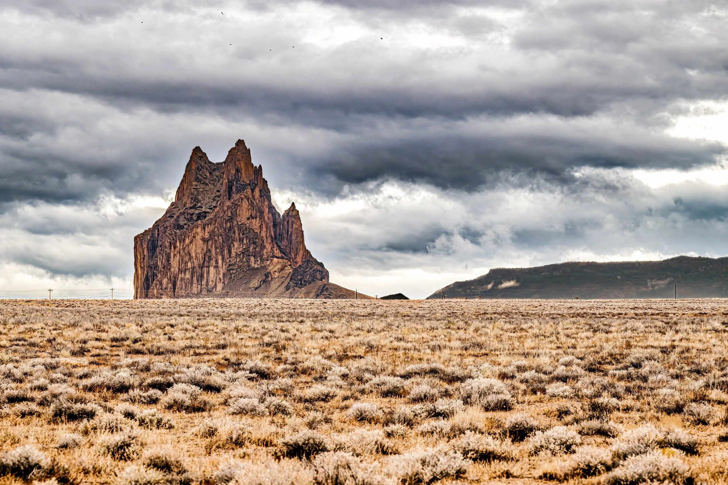
1. Indian Service Route 13
Location: Paved road that passes through the southern volcanic dyke
Distance from Formation: 1-2 miles at closest point
Access from US-491: Turn west onto Route 13 (also called Red Valley Road)
Why This is a great viewpoint:
Route 13 is the photographer's secret weapon for Shiprock. Here's why it's special: the road actually passes through the southern volcanic dyke—the dramatic rock wall that radiates from Shiprock like the wing of the stone bird.
This creates a natural leading line composition: the dyke cuts through the frame in the foreground, drawing the eye toward Shiprock rising in the distance. It's the kind of compositional gift landscape photographers dream about.
The Shot:
Stand on the east side of the dyke
Frame with the volcanic wall in the foreground left/right
Shiprock rises in the mid-distance
Use 200-400mm to compress the layers
Shoot at sunrise when the formation catches first light
The shoulder along Route 13 is narrow. Park completely off the road and watch for occasional traffic. It's a low-traffic paved route, but vehicles do come through.
Multiple Pullouts:
As Route 13 passes near the dyke, there are several small pullout areas. Each offers a slightly different angle. Scout them all—walk the road (carefully) and find your composition before sunrise.
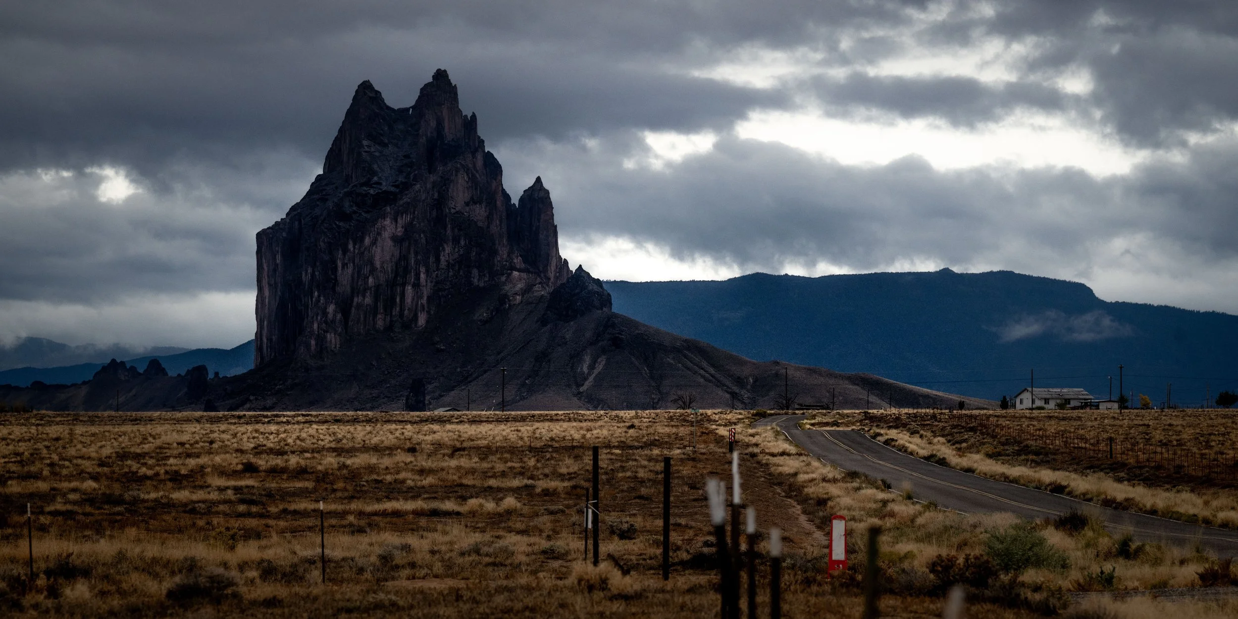
2. US Highway 491 (East Side Views)
Location: Major north-south highway east of Shiprock
Distance from Formation: 3-5 miles
Best Viewpoints: Multiple pullouts south of Shiprock town
US-491 offers the classic "Shiprock from the desert floor" perspective that most photographs show. From this angle, you see the full mass of the formation rising from the horizontal plain.
The Shot:
Best in late afternoon/sunset
Western light hits the east face
Include desert vegetation in foreground
Use 200-400mm to fill the frame
"Winged" shape is visible—the dykes radiating like wings
Advantage: Easier access, more pullout options, safer roadside parking
Disadvantage: Farther from formation, less dramatic foreground elements
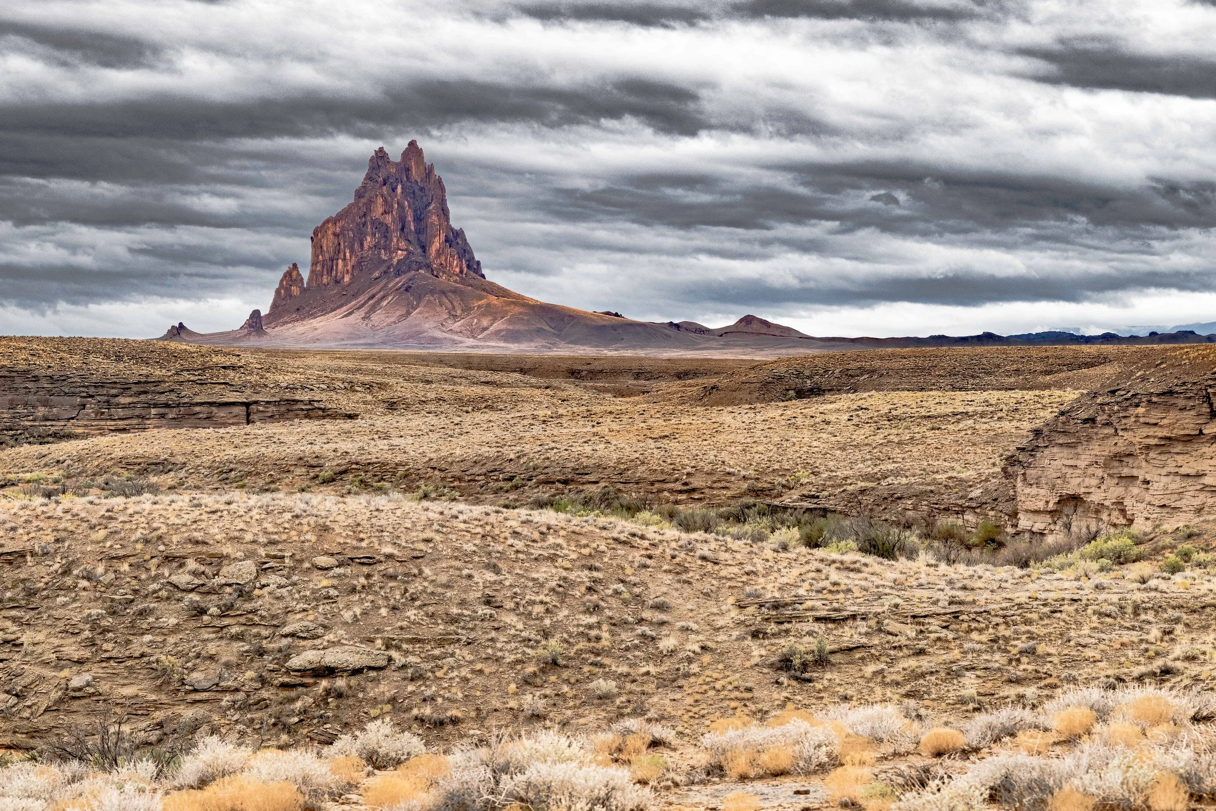
3. US Highway 64
Location: West of Farmington
Distance from Formation: 10-20 miles
For ultra-wide environmental shots showing Shiprock in the context of the vast Four Corners landscape, Highway 64 heading west from Farmington provides incredible views. These work best for showing the scale and isolation of the formation.
When to Use: Atmospheric conditions (storms, fog, dramatic clouds), telephoto compression from extreme distance
-
No. Hiking, climbing, and driving off-road at Shiprock are strictly prohibited. The formation is a sacred site (Tsé Bitʼaʼí) to the Navajo people. In 1970, the Navajo Nation banned all climbing to preserve its sanctity. Visitors must view and photograph the monolith only from paved roadways like US-491 and Route 13.
-
The famous "south dyke" is easily visible from Indian Service Route 13. From the town of Shiprock, drive south on US-491 for approximately 7 miles, then turn west onto ISR 13 (Red Rock Highway). Drive about 7-8 miles until you see the black volcanic wall running parallel to and eventually crossing the road.
-
Generally, no. The Navajo Nation has strict regulations regarding drone usage, especially near sacred sites like Shiprock. Recreational drone flights are typically prohibited without a specific permit from the Navajo Nation Film Office, and flying over the peak itself is considered culturally disrespectful.
-
Sunrise is ideal for the classic shot from Route 13, as the sun rises behind you and illuminates the dyke and the eastern face of the peak. Sunset is spectacular from US-491 (looking west), where the formation becomes a massive silhouette against the colorful desert sky.
🙏 Respecting Navajo Sacred Land
Monument Valley is not a National Park—it is Navajo Nation territory. Known to the Navajo as Tsé Biiʼ Ndzisgaii ("Valley of the Rocks"), this is sacred land and the home of the Navajo people.
Please Honor Navajo Laws and Culture:
✅ Stay on designated roads and trails
✅ Purchase from Navajo vendors (jewelry, crafts)
✅ Ask permission before photographing Navajo people
✅ Pack out all trash—keep the land clean
❌ NO drones (strictly prohibited by Navajo law)
❌ NO rock climbing on formations (sacred sites)
❌ NO dogs (prohibited at all Navajo Tribal Parks)
❌ NO spreading cremated remains (desecration)
❌ NO camping outside designated areas
Walking in Beauty (Hózhó): The Navajo concept of Hózhó represents living in harmony and balance with nature. Please visit with this spirit of respect.
Ready to Photograph Shiprock?
Shiprock teaches us something essential about photography: sometimes the most powerful images are the ones taken with restraint. You can't climb it, you can't approach it, you can't even drive close to it. And that distance—that enforced respect—is part of what makes the photographs matter.
When you photograph Shiprock, you're not just capturing a geological formation. You're documenting a sacred site from the only perspective you're allowed: at a distance, with reverence, with telephoto lenses reaching across the desert toward something you can see but never touch.
And somehow, that makes the images more powerful.
See the Complete 5-Day Southwest Itinerary Continue to Monument Valley
Last updated January 2026. Respect Navajo land and law.
© 2026 Don Mennig Fine Art Photography